Mountains, Dams & Nature
🏔 Mountains of Cyprus
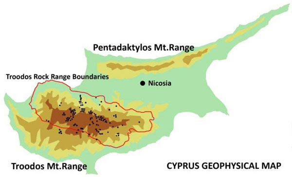
There are two main mountain systems on the island.
1. Troodos (Τρόοδος / Troodos)
Occupies the central and southwestern part of the island.
This is the "green heart" of Cyprus, consisting of volcanic rocks (ophiolite complex — a piece of ancient ocean crust pushed up from the sea floor).
- Highest point: Mount Olympus (Όλυμπος / Olympus) or Chionistra (Chionistra).
- Height: 1952 m.
- Interesting fact: In winter there is a ski resort here, and in summer it is the best place to escape the heat.
2. Pentadaktylos (Πενταδάκτυλος / Pentadaktylos)
A mountain range in the north (occupied), also known as the Kyrenia Mountains.
- Name: Means "Five-fingered" (Πέντε = five, Δάκτυλο = finger) due to the characteristic shape of one of the peaks.
- Rock type: Limestone (unlike the volcanic Troodos).
- Key castles: The castles of Saint Hilarion, Buffavento and Kantara are located on the peaks of this range.
📍 In the exam: What is the name of the highest mountain in Cyprus?
Answer: Olympus (Olympus) in the Troodos mountains.
⛰ Peaks by range
Troodos ridge, east → west: Machairas → Stavropefkos → Papoutsa → Adelfoi → Troodos → Kykkos → Tripylos.
Troodos spans four districts: Paphos, Nicosia, Limassol, Larnaca.
Pentadaktylos (Kyrenia range): along the north coast, from Kormakitis to Apostolos Andreas. Occupied.
| Peak | Greek | Range | Height | Note |
|---|---|---|---|---|
| Olympus / Chionistra | Όλυμπος (Χιονίστρα) | Troodos | 1,952 m | Highest point of Cyprus |
| Madari (Adelfoi summit) | Μαδαρή / Αδελφοί | Troodos | 1,613 m | Fire lookout; Pitsilia |
| Papoutsa | Παπούτσα | Troodos | — | Pitsilia; the Serrachis river rises here |
| Machairas / Kionia | Μαχαιράς / Κιόνια | Troodos | — | East end of the ridge; Machairas forest |
| Kykkos (Throni) | Κύκκος (Θρόνι) | Troodos | 1,318 m | Kykkos Monastery |
| Tripylos | Τρίπυλος | Troodos | — | West end of the ridge; Paphos Forest, Cedar Valley |
| Kyparissovouno | Κυπαρισσόβουνο | Pentadaktylos | 1,024 m | Highest of Pentadaktylos · no castle |
| Buffavento | Βουφαβέντο | Pentadaktylos | ~954 m | 🏰 Castle (highest of the three) |
| Pentadaktylos | Πενταδάκτυλος | Pentadaktylos | ~741 m | The "five fingers" crag that names the range |
| Agios Ilarionas (St Hilarion) | Άγιος Ιλαρίωνας | Pentadaktylos | ~725 m | 🏰 Castle above Kyrenia |
| Kantara | Καντάρα | Pentadaktylos | ~630 m | 🏰 Castle; easternmost, gateway to Karpasia |
Castles = only on Pentadaktylos: St Hilarion, Buffavento, Kantara.
📍 In the exam: Which of these is NOT a Pentadaktylos peak: Kantara, Kyparissovouno, Agios Ilarionas, Papoutsa?
Answer: Papoutsa — it is a Troodos peak (Pitsilia area).
💧 Water: Dams and Lakes
Cyprus rivers are seasonal: they flow in winter and dry up in summer. Only the upper Troodos stretches of a few (Xeros, Diarizos, Kargotis, Marathasa, Kouris, Germasogeia) flow all year. The rivers still have names and mouths (see below). Water is therefore stored in reservoirs (dams).
🌊 Rivers and where they flow
Most rivers rise in the Troodos. Pentadaktylos sends only short streams.
| River | Greek | Length | Flows into | Note |
|---|---|---|---|---|
| Pedieos | Πεδιαίος | 98 km — longest | Famagusta Bay | Crosses Nicosia and the Mesaoria |
| Gialias | Γιαλιάς | 88 km — 2nd | Famagusta Bay | Passes Dali (Idalion) |
| Serrachis | Σερράχης | 55 km — 3rd | Morphou Bay | Rises at Papoutsa; the Ovgos (Οβγός) joins it just before the bay |
| Diarizos | Διάριζος | 42 km | Paphos coast | Mostly Paphos district; Arminou dam; tunnel to Kouris dam |
| Xeros Potamos | Ξερός Ποταμός | 41.5 km | Paphos coast | Asprokremmos dam |
| Ezousa | Έζουσα | 41 km | Paphos coast | Kannaviou dam |
| Kouris | Κούρης | — | Episkopi Bay | Kouris basin = Kouris + Limnatis (Λιμνάτης) + Kryos (Κρυός) → Kouris dam |
📍 In the exam: The Serrachis and Ovgos rivers flow into the bay of …
Answer: Morphou. (Pedieos and Gialias → Famagusta Bay; Kouris → Episkopi Bay.)
The six bays (Κόλποι)
| Bay | Greek | District | Rivers ending here |
|---|---|---|---|
| Famagusta Bay — largest | Κόλπος Αμμοχώστου | Famagusta (occupied part) | Pedieos, Gialias |
| Morphou Bay | Κόλπος Μόρφου | Occupied north-west | Serrachis + Ovgos |
| Episkopi Bay | Κόλπος Επισκοπής | Limassol | Kouris |
| Akrotiri Bay | Κόλπος Ακρωτηρίου | Limassol — Limassol town is mid-bay | — |
| Larnaca Bay | Κόλπος Λάρνακας | Larnaca | — |
| Chrysochou Bay | Κόλπος Χρυσοχούς | Paphos — Cape Akamas to Pomos (Polis, Latchi) | — |
⚠️ "Limassol Bay" is not one of the six — Limassol sits on Akrotiri Bay.
Main dams (Φράγματα)
| Dam | Description |
|---|---|
| Kouris Κούρης | The largest (115 million m³). Located above Limassol. |
| Asprokremmos Ασπρόκρεμμος | The second largest, in the Paphos district. |
| Evretou Ευρέτου | The third, also in the Paphos district. |
Top-10 list with rivers and years: chapter Water & Environment.
📍 In the exam: What is the name of the largest dam in Cyprus?
Answer: Kouris (Kouris).
Salt lakes (Aliki / Αλυκή)
In summer they dry up and are covered with salt, and in winter they fill with rainwater and become home to migratory birds.
- Larnaca Salt Lake: Known for the Hala Sultan Tekke mosque on its shore.
- Limassol Salt Lake (Akrotiri): The largest in area, but shallower than Larnaca.
🌿 Natural attractions
Akamas Peninsula (Ακάμας)
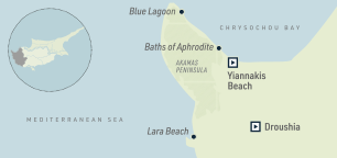
A wild nature reserve in the west of the island (Paphos district). A place where turtles lay their eggs (Lara Beach). Here is the Avakas Gorge (Avakas Gorge).
Kavo Greko (Cape Greco / Κάβο Γκρέκο)
The southeasternmost point of the Republic of Cyprus. A National Forest Park with sea caves and crystal-clear water.
Waterfalls
Mainly located in the Troodos mountains and active in winter/spring.
- Millomeris (Millomeris) — the highest (~20 m), in Platres.
- Caledonia (Caledonia) — the most popular (13 m), in the Troodos National Forest Park (Δάσος Τροόδους), with a beautiful trail leading to it from Pano Platres.
- Chantara (Χαντάρα) — 8 m, by the village of Foini.
📍 Nature sites → district
Typical question: "Which of these is in X district?" Learn the district.
| District | Site | Greek | What it is |
|---|---|---|---|
| Paphos | Avakas Gorge | Φαράγγι του Άβακα | Gorge on the Akamas peninsula; micro-reserve for an endemic plant |
| Paphos | Aphrodite & Adonis trails | Μονοπάτι Αφροδίτη / Άδωνις | Akamas loops from the Baths of Aphrodite |
| Paphos | Cedar Valley | Κοιλάδα των Κέδρων | Inside Paphos Forest (Tripylos); thousands of endemic Cyprus cedars |
| Paphos | Stavros tis Psokas | Σταυρός της Ψώκας | Forest station in Paphos Forest; mouflon |
| Paphos | Petra tou Romiou | Πέτρα του Ρωμιού | Aphrodite's Rock, south-west coast: in myth, Aphrodite was born from the sea foam here |
| Paphos | Baths of Aphrodite | Λουτρά της Αφροδίτης | Grotto with a spring past Latchi harbour, on the way to Akamas. In myth, Aphrodite bathed here and met Adonis |
| Limassol | Caledonia waterfall & trail | Καταρράκτης Καληδονιών | Kryos river above Pano Platres, in the Troodos National Forest Park (Δάσος Τροόδους) |
| Limassol | Millomeris waterfall | Καταρράκτης Μυλλομέρη | Platres |
| Limassol | Chantara waterfall | Καταρράκτης Χαντάρα | Foini, Trooditissa–Foini trail |
| Limassol | Artemis & Persephone trails | Μονοπάτι Άρτεμις / Περσεφόνη | Troodos: round the Olympus summit / from Troodos Square |
| Limassol / Nicosia | Atalante trail | Μονοπάτι Αταλάντη | Troodos: 14 km loop round Chionistra |
| Limassol | Troodos Botanical Garden «A.G. Leventis» | Βοτανικός Κήπος Τροόδους «Α.Γ. Λεβέντης» | On the old Amiantos asbestos mine, 1,400 m (since 2004) |
| Limassol | Akrotiri Salt Lake | Αλυκή Ακρωτηρίου | Largest inland water body; inside the British base |
| Nicosia | Platania picnic site | Πλατάνια | 6 km from Kakopetria; largest forest picnic site (2,900 people) |
| Nicosia | Kionia | Κιόνια | Picnic site in Machairas forest, 1,340 m |
| Nicosia | Madari fire lookout | Μαδαρή | Adelfoi forest, 1,613 m |
| Nicosia | Athalassa dam / park | Φράγμα Αθαλάσσας | South-east edge of Nicosia; bird hide |
| Larnaca | Kamares Aqueduct | Υδραγωγείο Καμάρων | Built 1746 by Bekir Pasha to bring water to Larnaca |
| Larnaca | Larnaca Salt Lake | Αλυκή Λάρνακας | Flamingos; Ramsar site |
| Larnaca | Oroklini Lake | Λίμνη Ορόκλινης | Wetland, Natura 2000 |
| Larnaca | Rizoelia | Ριζοελιά | Forest park and picnic site by Aradippou |
| Famagusta | Paralimni Lake | Λίμνη Παραλιμνίου | Seasonal lake, free area, Natura 2000 |
| Famagusta | Cape Greco | Κάβο Γκρέκο | Forest park; has its own "Aphrodite" trail (same name as Akamas) |
📍 In the exam: Which of these is in Larnaca district: Avakas Gorge, Kamares Aqueduct, Caledonia waterfall, Platania?
Answer: The Kamares Aqueduct.