Division & Special Zones
After the Turkish invasion of 1974, Cyprus remains a divided island. This is not abstract politics — it is a reality you will encounter: checkpoints, the buffer zone, British bases.
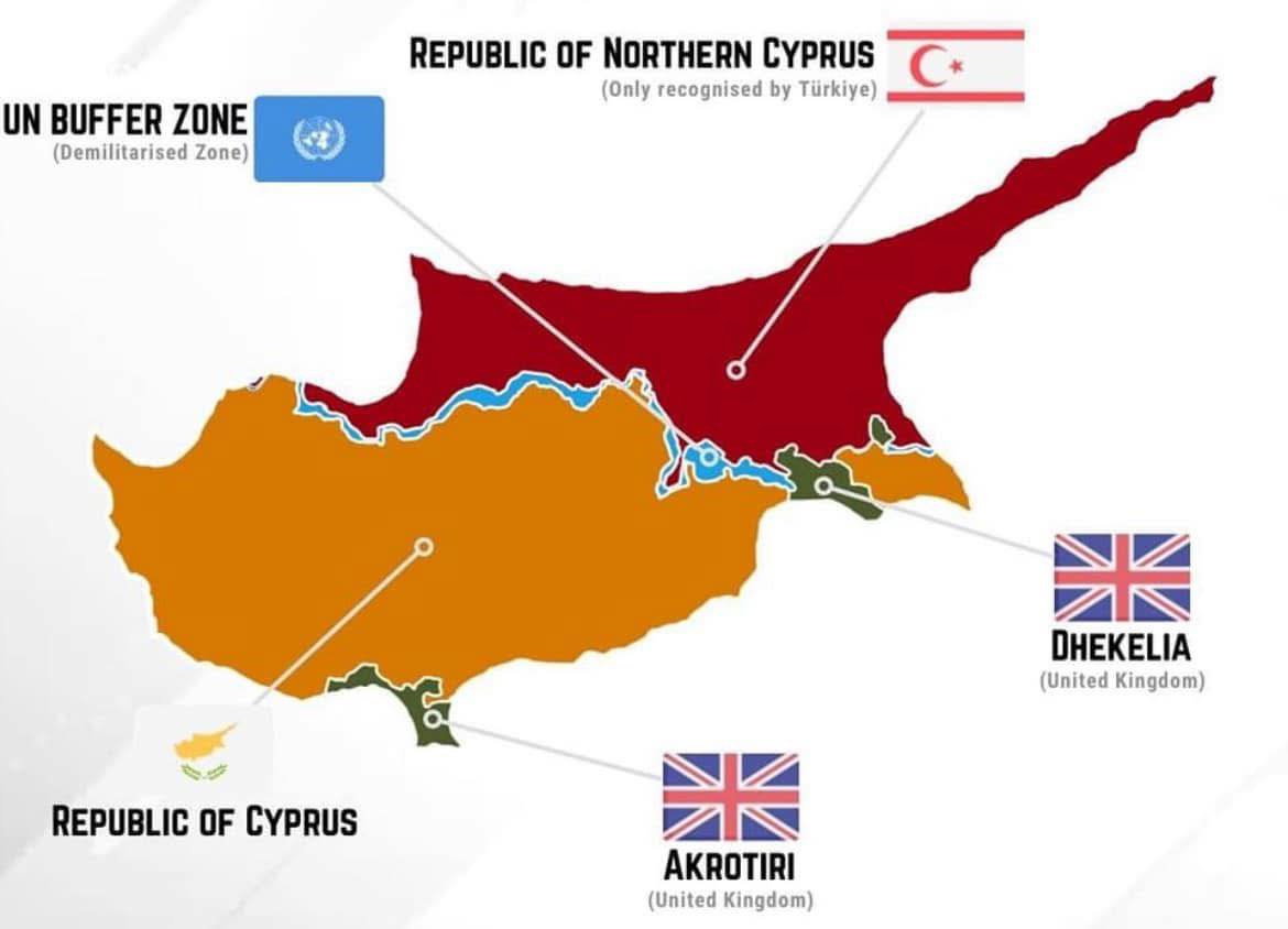
Zones of control
| Zone | Area | Who controls it |
|---|---|---|
| Republic of Cyprus | ~60% | Legitimate government |
| Occupied zone | 36.2% | Turkey / “TRNC” |
| Buffer zone | ~3% | UN (UNFICYP) |
| British bases | ~2.7% | United Kingdom |
❓ What percentage of the territory of Cyprus is occupied?
→ 36.2%
❓ Entry into which area of Cyprus is considered illegal?
→ Entry via the ports and airports of the occupied territory (see below)
Occupied territories
Invasion: 20 July 1974
Self‑proclaimed state: “Turkish Republic of Northern Cyprus” (ΤΔΒΚ / “TRSK”, Turétskaya Respublika Sévernogo Kípra) — declared in 1983
Recognition: Only Turkey. The rest of the world regards this as an illegal occupation.
What this means in practice
- No international flights to the north (only via Turkey)
- No embassies of other countries
- Economic isolation
- EU law does not apply
❓ Which countries recognize the “TRNC”?
→ Only Turkey
Legal and illegal entry
✅ LEGAL: Entry via the Republic of Cyprus
Fly into the airports:
- Larnaca (LCA)
- Paphos (PFO)
After that you can cross the dividing line via official checkpoints.
❌ ILLEGAL: Direct entry to the north
You may not enter Cyprus via:
- Ercan Airport on the north
- The ports of Famagusta or Kyrenia
Why: From the point of view of the Republic of Cyprus, this is illegal entry into its territory. You may face problems:
- Fine or future entry ban
- Legal complications with property
- Problems when applying for citizenship
❓ Entry into which area is considered illegal?
→ Entry via ports/airports of the occupied territory (the north)
⚠️ Important: Visiting the north via checkpoints after legal entry to the south is permitted.
The Green Line
The buffer zone that divides the island from west to east — 180 km.
Why “green”? In 1963 a British general drew the dividing line with a green pencil on a map of Nicosia.
Who guards it: UN peacekeepers — UNFICYP (United Nations Peacekeeping Force in Cyprus). On the island since 1964.
Width: From a few metres (in central Nicosia) to several kilometres (in rural areas).
Checkpoints (crossing points)
Since 2003 the line can be crossed via official checkpoints. A passport or ID is required.
Main checkpoints
| Checkpoint | Where | Type |
|---|---|---|
| Ledra Street | Centre of Nicosia | Pedestrians only |
| Ledra Palace | Nicosia | Pedestrians (+ diplomats) |
| Agios Dometios (Metehan) | Nicosia | Vehicle |
| Pergamos | East (Larnaca district) | Vehicle |
| Strovilia | Through the Dhekelia base | Vehicle |
| Astromeritis | West of Nicosia | Vehicle |
| Lefka/Apliki | West | Vehicle |
What is checked:
- Passport or ID card
- They may ask your purpose of visit
- Car insurance (a separate one is needed for the north)
💡 Tip: Ledra Street is the most convenient for tourists. You simply walk across through the centre of Nicosia.
British Sovereign Base Areas (SBA)
These are territory of the United Kingdom — not part of the Republic of Cyprus and not part of the EU.
| Base | Where | Area |
|---|---|---|
| Akrotiri (Akrotiri) | South, near Limassol | ~123 km² |
| Dhekelia (Dhekelia) | South‑east, between Larnaca and Ayia Napa | ~51 km² |
Why are they here? Under the 1960 Treaty of Establishment of the independence of Cyprus, Britain retained these territories.
What is there:
- RAF military bases (Royal Air Force)
- Radars and listening stations
- Residential areas for servicemen and their families
On Mount Olympos (Troodos) there is a British radar station.
❓ What are the names of the two British bases in Cyprus?
→ Akrotiri and Dhekelia
Special places
Village of Pyla (Πύλα, Píla)
The only place in the buffer zone where Greeks and Turks live together. Located in the Larnaca district.
There is both a Greek church and a mosque here, as well as coffee houses of both communities. Patrolled by the UN.
Varosha (Βαρώσια / Varosha)
A district of Famagusta — a ghost town since 1974. Residents fled, thinking they would return in a few days. They have not returned to this day.
Until 1974 it was a popular resort visited by celebrities. Now it is abandoned hotels behind barbed wire.
Karpas Peninsula (Καρπασία, Karpasía)
The “finger” in the north‑east of the island. Fully occupied.
There is the Monastery of Apostle Andrew — an important place of pilgrimage. Greek Cypriots can visit it via checkpoints.
❓ Where is the Monastery of Apostle Andrew located?
→ On the Karpas Peninsula (occupied territory)
Key points to remember
| Fact | Answer |
|---|---|
| Percentage of occupation | 36.2% |
| Who recognizes the “TRNC” | Only Turkey |
| UN peacekeepers | UNFICYP (since 1964) |
| British bases | Akrotiri and Dhekelia |
| Illegal entry | Via ports/airports of the north |
| Legal entry to the north | Via checkpoints after flying to the south |
| Pedestrian checkpoint in Nicosia | Ledra Street |
| Village of the two communities | Pyla |
| Ghost town | Varosha |